Before you go, check the latest Tonto National Forest conditions, weather forecast, and any trail or road closures that could affect your visit.
The Story Behind the Railroad Tunnel
In the early 1880s, the Arizona Mineral Belt Railroad planned to build a rail line connecting Globe to the Atlantic & Pacific Railroad in Flagstaff. The idea was ambitious. The railroad would have helped move ore and supplies across some of Arizona’s most rugged terrain, including the Mogollon Rim. The Forest Service notes that the tunnel project was part of that greater effort, but the railroad was never completed.
The original plan reportedly called for a tunnel of roughly 3,100 feet through the Rim. Only a portion was completed before the project was abandoned. Arizona Hiking reports that about 700 feet were excavated before funding ran out, leaving behind the tunnel entrance that hikers can still visit today.
That unfinished tunnel is what makes the hike so interesting. It is not just another forest trail. It is a walk into a forgotten piece of Arizona history.
Where the Trail Begins

The Railroad Tunnel hike begins near Washington Park and follows Colonel Devin Trail before connecting to the historic tunnel route.
Most hikers access the Railroad Tunnel Trail from the Washington Park Trailhead, north of Payson. From Payson, the route generally follows Highway 87 toward Pine and Strawberry, then turns onto Houston Mesa Road and continues toward Washington Park. Arizona Hiking describes the access route as leaving Payson on Highway 87, turning onto Houston Mesa Road, continuing through Whispering Pines, and then following Forest Road 32 to the Washington Park Trailhead. From the trailhead, hikers typically follow Colonel Devin Trail #290 and then connect to Railroad Tunnel Trail #390.
What to Expect on the Hike?
The hike begins in a peaceful forest setting near the East Verde River. However, your hiking experience will largely depend on the season and recent rainfall. Hikers may find shaded stretches, greenery, small springs, and a quiet canyon atmosphere. The route is especially appealing because it feels tucked away, despite being just a short drive from Payson.
The out-and-back hike is commonly described as about 4 miles total, with approximately 1,000 feet of elevation gain.
- Arizona Hiking rates it as moderate and notes that the final section near the tunnel becomes steeper and rockier.
- AllTrails also lists the route as being in Tonto National Forest and notes that hikers should expect rocky terrain and some scrambling, so sturdy footwear is a good idea.
Explore the Historic Tunnel and Stone Ruins

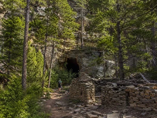
Old stonework near the tunnel site offers a glimpse into the abandoned railroad project below the Mogollon Rim
One of the highlights of the hike is the stone powder house near the tunnel site. These old stone walls are a reminder that this was once an active work area, not just a scenic destination. The stacked stone, fallen logs, rocky slope, and dark tunnel entrance give the area a rugged, historic character that makes it stand out from other Payson-area hikes.
The tunnel itself is easy to miss until you are close to it. That final approach is part of the fun. The forest opens into a rocky area, the old stonework appears, and then the dark tunnel entrance comes into view. It feels like discovering a hidden landmark.
A Hike With Mogollon Rim Character

The Railroad Tunnel trail has the classic feel of Rim Country. There are tall pines, rocky drainages, ledges, canyon walls, and views toward the high country. It also connects hikers to the broader history of the Mogollon Rim, where old routes, cabins, military trails, railroad dreams, and mining-era ambitions all crossed paths.
Colonel Devin Trail itself has a historic connection. The Forest Service explains that the trail was named after Colonel Thomas C. Devin, who led Fort Whipple military personnel through the area during a maneuver involving Apache conflicts.
That layered history of Railroad Tunnel gives the area more depth than many casual hikers might expect. You are not just hiking to a tunnel. You are walking through a corridor that has been used for travel, military movement, railroad planning, and modern recreation.
Is There Any Other Way to Reach the Tunnel?
There is also an alternate way to reach the tunnel from above near the Mogollon Rim and Forest Road 300. This route can be shorter, but it is generally steeper and can be loose or slippery. For most visitors, especially those coming from Payson, the Washington Park route offers the more complete experience.
The Washington Park approach gives hikers the forest, the creek corridor, the historic trail connection, and the gradual build-up to the tunnel site.
What Is the Best Time to Hike on Railroad Tunnel Trail?
- Spring through fall is generally the best season for this hike.
- Arizona Hiking lists April through September as favorable months and specifically warns hikers to watch for monsoon weather in July through September.
- Early summer can be beautiful because of the greenery, while fall can bring cooler temperatures and changing light in the canyon.
- Winter conditions can vary, especially near the Rim, so check road and trail conditions before heading out.
Trail Tips Before You Go
- Bring more water than you think you need, especially in warm weather.
- Wear hiking shoes with good traction because the final approach to the tunnel is rocky and steeper than the earlier part of the hike.
- Be careful around loose rock, old stonework, and the tunnel entrance.
- Historic sites should be enjoyed respectfully, which means leaving the stones, artifacts, and tunnel area as you found them.
- Dogs are allowed on the Railroad Tunnel Trail via the Arizona Trail route according to AllTrails, but they should remain on leash.
Why This Trail Belongs on a Payson Hiking List

The Railroad Tunnel Trail is a perfect example of what makes Payson and Rim Country special. Within a short drive of town, you can find forest trails, flowing water, historic ruins, canyon views, and access to the Mogollon Rim. It is not the most famous hike in Arizona, but that is part of its appeal.
- For people who live in Payson, Pine, Strawberry, or nearby Rim Country communities, places like this are part of everyday access to the outdoors.
- For visitors, it is a reminder that Payson is more than a stop on the way to the Rim. It is a gateway to some of Arizona’s most interesting high-country trails.
Frequently Asked Questions About the Railroad Tunnel Trail
Can I actually go inside the abandoned tunnel?
You can walk right up to the entrance and peer inside, but going deep into the tunnel is a bad idea. Because it was never finished or braced with modern supports, the rock ceiling is unstable, and chunks of stone can fall without warning. It is also completely dark, pitch black, and serves as a natural shelter for local wildlife like bats, javelinas, or snakes that you probably do not want to disturb.
Is the road to the trailhead okay for a regular sedan?
You can get to the Washington Park Trailhead in a normal car, but you need to drive slowly. The final stretch on Forest Road 32 is a dirt road that can get quite bumpy, rutted, and muddy, especially after a good rain or during the summer monsoon season. If your car sits very low to the ground, just take your time exploring the rougher spots.
Why is there an old stone building near the tunnel?
That little stone ruin is an old powder house. Back in the 1880s, workers used it to safely store their blasting powder and dynamite away from the main construction area. Because blasting materials were highly dangerous and could explode from heat or sparks, building a thick stone house tucked against the mountain was the safest way to keep the camp from blowing up.
How hard is the climb on this hike?
The first half of the trail is a pretty steady, gradual walk through the pine trees. However, the last stretch up to the tunnel entrance gets your heart pumping. It becomes quite steep, and the ground turns into loose gravel and rocky scree (loose stones on a slope). You will want to take your time on this final section so you do not slip and slide on the way up or down.
Takeaway
The Railroad Tunnel Trail is easily one of the most interesting hikes near Payson because it feels like a walk through a giant outdoor museum. The unfinished tunnel is a cool destination, but walking past the old stone ruins and tracking the old path up the mountain is just as fun. It gives you a great mix of high-country pine forest, wide views, and a neat history lesson all at once.
If you want a hike that offers something a bit different than just trees and rocks, this trail is definitely worth checking out.
Explore Railroad Tunnel With Dennis Riccio Like Never Before
The builders of the 1880s railroad had a massive vision for Rim Country, even if they never quite finished the tracks. Today, people are still coming to the Payson area to build their own futures among the pine trees. If you want to stop just hiking through Arizona history and start making your own, finding the right property is your next step.
Dennis Riccio knows how to find the hidden gems in the local housing market that other people completely miss. As a West USA Realty agent, the President of the Central Arizona Association of REALTORS, and a practicing real estate attorney, Dennis brings a lot more to the table than a standard agent. He understands the unique history of the local land, knows which neighborhoods are best for your lifestyle, and protects you from any hidden legal surprises when you buy or sell a home.
You do not need an old map to find your perfect mountain retreat. Call Dennis Riccio today at (928) 517-4550 to start your next chapter in Rim Country.
Helpful Links: U.S. Forest Service, Colonel Devin Trail #290 and Railroad Tunnel Trail #390 Arizona Hiking, Railroad Tunnel via AZ Trail AllTrails, Railroad Tunnel Trail via Arizona Trail |